Digital Eyes in Earth's Orbit
How artificial intelligence and computer vision are redefining satellite imagery for daily corporate and consumer life
SCIENSENEW SPACE
By Marcelo Salamon
7/1/20266 min read
Abstract
Satellite observation of the Earth generates a massive, continuous influx of geospatial data that vastly outpaces traditional human analysis. This paper examines the historical and contemporary integration of Artificial Intelligence (AI), with a core emphasis on deep neural networks and computer vision, in automating the processing of these orbital images. It discusses foundational architectures like Convolutional Neural Networks (CNNs), the fusion of multispectral data, and practical everyday breakthroughs across precise agriculture, commercial supply chains, and consumer mapping tools. Finally, it addresses the challenges of cloud obstruction and the shift toward Edge AI in orbital hardware, establishing AI as the driving engine of modern global data logistics.
Keywords: Artificial Intelligence; Satellite Imagery; Computer Vision; Remote Sensing; Deep Learning.
Introduction
Ever since the launch of the first artificial spacecraft in the mid-twentieth century, humanity’s ability to observe the Earth from outer space has radically transformed cartography, meteorology, and environmental sciences. However, for decades, the remote sensing paradigm faced a severe operational bottleneck: the vast asymmetry between the speed of data collection and the human capacity for processing and interpretation. Modern satellites, operating in low Earth orbit (LEO) constellations, transmit petabytes of raw data daily, blanketing the globe with unprecedented spatial and temporal resolutions. Manually inspecting this voluminous torrent of pixels for everyday business patterns or subtle ground anomalies quickly became an impossible task for human eyes.
The technological breakthrough that overcame this historic barrier arrived over the past decade through the convergence of space infrastructure and Artificial Intelligence, specifically Deep Learning algorithms and Computer Vision. This synergy enabled the automatic conversion of complex, static images into dynamic streams of strategic, actionable intelligence. Far from being a mere tool for basic visual automation, AI operates as a cognitive amplifier. It is capable of identifying structural micro-events, predicting crop behaviors, tracking unmapped changes on the ground, and anticipating commercial supply chain disruptions long before they impact the general public. This article explores this expanding technological ecosystem, detailing its computational foundations, its daily commercial applications, and the upcoming frontiers in orbital computing.
Technological Foundations of Space-Based AI
Automated analysis of satellite imagery differs substantially from the processing of everyday smartphone photos or medical scans. Orbital data is inherently complex, subject to atmospheric distortion, varying solar angles, and geometric warping caused by the Earth’s curvature. To translate this heterogeneous mass of data into reliable knowledge, software engineers deploy advanced architectures based on Convolutional Neural Networks (CNNs). These networks operate by mimicking the human visual cortex, progressively extracting features from an image through multiple convolutional layers. In the initial stages, the algorithm detects simple geometric elements such as edges, sharp lines, and contrasts. In subsequent layers, these basic shapes are grouped together to identify highly complex structures like cargo ships, specific crop rows, urban grids, or hidden clearings in dense canopies.
Beyond recognizing spatial shapes, Artificial Intelligence has revolutionized spectral interpretation. While human sight is strictly limited to the visible light spectrum (RGB), modern satellite sensors capture multispectral and hyperspectral data, recording wavelengths that include near-infrared, shortwave infrared, and radar waves. AI can process dozens of these hidden layers simultaneously, identifying the unique "chemical signature" of objects on the Earth's surface. This makes it possible to differentiate between a plastic tarp and a body of water from hundreds of miles away, determine the precise water stress level of a forest, or quantify deep soil moisture levels without digging a single hole.
Another foundational pillar is Data Fusion. The most robust AI models do not limit their analysis to an isolated satellite picture. Instead, they integrate orbital pixel arrays with diverse terrestrial datasets, including historical weather series, local cartographic registries, live transponder signals from commercial maritime fleets (AIS), and internet-of-things (IoT) sensors installed on the ground. The result of this fusion is a multidimensional analytical model, where a satellite image ceases to be a mere photograph and becomes an active, intelligent node within a vast network of integrated global data.
Practical Applications and Daily Commercial Impact
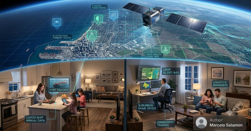
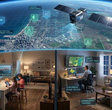
The practical impact of AI-driven remote sensing has reconfigured business models and public resource management around the globe, shifting heavily into the daily routines of businesses and consumers. In modern agriculture, traditional physical field sampling has been widely replaced by satellite-driven precision farming. AI algorithms continuously monitor millions of acres, calculating vegetation indices to map soil health and predict crop yields with error margins below three percent. Even more critically, neural networks can isolate subtle color anomalies in leaves, issuing automated alerts about localized pest outbreaks or nutrient deficiencies weeks before the damage becomes visible to a farmer walking the field.
Beyond large-scale farming, this technology directly shapes the daily consumer economy and corporate retail logistics. Financial institutions, hedge funds, and commodity traders routinely use computer vision to analyze the occupancy rates of retail parking lots outside major shopping malls worldwide, allowing them to accurately deduce retail health, consumer spending habits, and market fluctuations ahead of quarterly earnings reports. Similarly, logistics companies track the real-time density of container ships anchored at global ports, optimizing supply chains and informing daily consumer delivery estimates. Even everyday smartphone applications, such as digital maps, ride-sharing platforms, and real-time traffic navigators, rely heavily on background AI models that automatically update maps, detect road closures, and identify newly constructed pathways from satellite feeds without human intervention.
In insurance and real estate, everyday workflows have been completely transformed. Insurance companies utilize automated visual AI to assess property damage immediately following storms, floods, or wildfires, allowing them to process consumer claims and disburse payouts in hours rather than weeks. Real estate developers use the same algorithms to evaluate neighborhood growth patterns, urban density, and infrastructure quality before making everyday investment decisions. On an environmental scale, governments and non-governmental organizations deploy automated systems that compare daily images to detect illegal logging or unauthorized construction almost in real time, turning satellite data into a vital shield for ecosystem preservation.
Contemporary Challenges and Future Frontiers
Despite its exponential progress, applying AI to remote sensing faces harsh physical and operational obstacles. The primary natural barrier to optical observation is cloud cover, which obstructs the view of the Earth's surface across more than sixty percent of the globe at any given moment. To bypass this limitation, data scientists have developed advanced neural networks based on Generative Adversarial Networks (GANs) specialized in "cloud removal." These networks are trained to predict and reconstruct hidden surface details by cross-referencing historical data with Synthetic Aperture Radar (SAR) sensors. Because radar waves seamlessly penetrate atmospheric moisture and thick cloud layers, the AI can generate accurate three-dimensional surface maps regardless of adverse weather conditions or a total absence of sunlight.
Another disruptive frontier addresses data transmission infrastructure. Sending massive volumes of high-resolution images from space down to receiving stations on Earth requires immense bandwidth and creates critical delays, known as latency. The emerging solution is Edge Computing in Space, or Orbital Edge AI. This involves installing specialized hardware with dedicated neural acceleration chips directly onto the satellites. Instead of beaming gigabytes of raw imagery down to terrestrial servers for heavy processing, the satellite executes the AI model while still in orbit. It analyzes the images mid-flight and transmits only the final insight or critical alert down to Earth—such as the exact coordinates of a newly detected structural failure or an emerging wildfire. This approach slashes data latency from days down to a few minutes, drastically accelerating response times when every second counts.
Conclusion
The fusion of Artificial Intelligence and satellite technology represents a major evolutionary leap in how humanity manages, understands, and interacts with the planet on a daily basis. By automating visual cognition over macroscopic datasets, AI has filled the operational gap that once constrained classic remote sensing. The benefits of this symbiosis extend horizontally across modern civilian life, insulating grocery supply chains against climate surprises, giving businesses immediate logistics clarity, providing surgical tools for environmental protection, and enhancing the digital apps that consumers navigate every single day.
As the costs of launching satellites continue to drop and the processing power of microchips advances, orbital intelligence will become increasingly omnipresent, fast, and embedded in daily life. The remaining technical hurdles, such as weather obstructions and transmission bottlenecks, are finding robust answers in synthetic data modeling and edge processing. Ultimately, equipping satellites with autonomous analytical minds provides our civilization with a perennially watchful, intelligent set of digital eyes, capable of safeguarding our present and anticipating our future from the final frontier of space.
References
LI, Y.; CHEN, W.; ZHANG, Y. Deep Learning for Remote Sensing Image Classification: A Comprehensive Review. IEEE Geoscience and Remote Sensing Magazine, vol. 8, no. 4, pp. 116-133, 2020.
MAURYA, R.; SINGH, A. K. Edge Computing in Satellite Networks: Architectures, Applications, and Challenges. Journal of Aerospace Information Systems, vol. 22, no. 2, pp. 89-104, 2024.
REICHSTEIN, M. et al. Deep learning and process understanding for data-driven Earth system science. Nature, vol. 566, no. 7743, pp. 195-204, 2019.
ZHU, X. X. et al. Deep Learning in Remote Sensing: A Review. IEEE Geoscience and Remote Sensing Magazine, vol. 5, no. 4, pp. 8-36, 2017.
Contact
Contact us for questions or suggestions
contact@turingvision.com
fone: + 55 54 99122 0659
© 2026. All rights reserved. https://turingsvision.com/privacy-policy